
PART0 » History » Version 4
« Previous -
Version 4/43
(diff) -
Next » -
Current version
COLIN, Tony, 03/03/2016 12:20 PM
PART 1 : An introduction to Navigation.
- Table of contents
- PART 1 : An introduction to Navigation.

Before anything else, it is necessary to tackle the origin of navigation and its applications, the creation of the current GNSS with a comparison of different systems and finally, describing the main principles of GPS.
1 - History of Navigation.
Navigation is a field of study that focuses on the process of monitoring and controlling the movement of a craft or vehicle from one place to another.[1] The field of navigation includes four general categories: land navigation, marine navigation, aeronautic navigation, and space navigation.


a- Visual navigation.
Seamark and landmark references > Limited range, Limited accuracy, Low availability of marks, Stars only during night and clear sky.
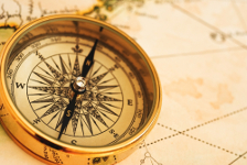
b- Navigation with classic instruments
Magnetic compass, Sextant > Measurement of the height of stars above the horizon providing longitude inaccurately > Use of ephemeris and time reference
Improvements by combining it with Harrison's clock (Chronometer) providing latitude and longitude with acceptable accuracy.
2 - Global Navigation Satellite System (GNSS).
a- History.
- Sputnik in 1957 : first satellite in the world, orbit estimated using the received signal frequency : Doppler effect.
- TRANSIT from 1958 operational in 1964 : first satellite navigation system for the US Navy.
- GPS program started at 1973 providing position anywhere at anytime.
b- Current definition.
Global Navigation Satellite System (GNSS) is a system of satellites that provide autonomous spatial positioning on Earth with global coverage.
It allows small electronic receivers to determine their location (longitude/latitude/altitude) to high precision (within a few meters) using time signals transmitted along a line of sight by radio from satellites.
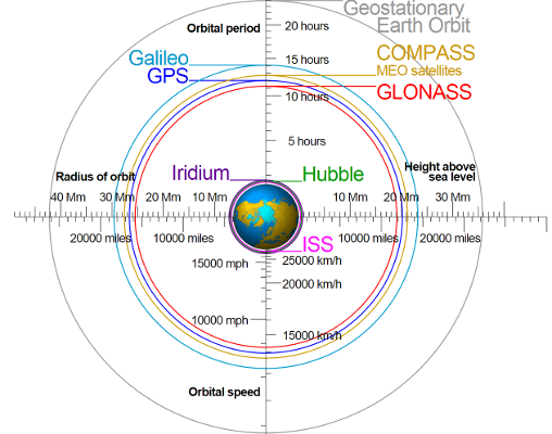
Global coverage for each system is generally achieved by a satellite constellation of 20–30 medium Earth orbit (MEO) satellites spread between several orbital planes. The actual systems vary, but use orbital inclinations of >50° and orbital periods of roughly 12 hours.
3 - Comparison of systems.

4 - Our system : GPS details.
http://www.gps.gov/systems/gps/space/
https://en.wikipedia.org/wiki/Global_Positioning_System
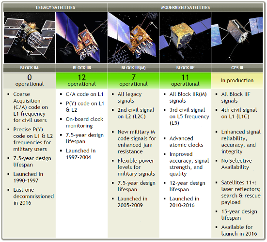
a- Space Segment.

b- Ground Control Segment.
Continuously > Track GPS satellites, estimate clock and orbit, keep GPS time, upload data that describes clock & orbit for each satellite
Infrequently > Command small maneuvers to maintain orbit, small clock corrections, major relocations to compensate any satellite failure
c- Delivery of Navigation messages.
Clock & Ephemeris sent by GS to SS, Spread Spectrum ranging signals & navigation data sent by SS to US & GS.
d- Signals.
p=.!2.png!
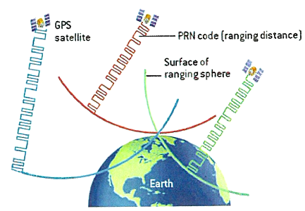
e- Ranging.
Propagation time : Time of transmission - Time of reception
Distance between satellite and receiver \approx Propagation time x Speed of light
attachment:"How it works 29.pdf"
In geometry, trilateration is the process of determining absolute or relative locations of points by measurement of distances, using the geometry ofcircles, spheres or triangles. :
1 measurement : 1 sphere of radius D1 centered in Sat1
2 measurements : intersection of 2 spheres (D1, Sat1) (D2, Sat2) = Circle
3 measurements : intersection of 3 spheres (D1, Sat1) (D2, Sat3) (D2, Sat3) = 2 points (1 often aberrant)
f- GNSS Receivers.


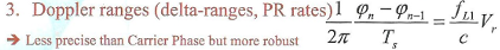
g- GNSS Measurements.

References :
[1] M. Sahmoudi, Introduction to satellite positioning & multi-sensor navigation, 2016
[2] K. Borre, D. M. Akos, N. Bertelsen, P. Rinder, S. H. Jensen, A software-defined GPS and GALILEO receiver
[3] https://en.wikipedia.org/wiki/Satellite_navigation
[4] https://en.wikipedia.org/wiki/Global_Positioning_System
[5] http://www.gps.gov/systems/gps/