
System and signal description » History » Version 4
« Previous -
Version 4/20
(diff) -
Next » -
Current version
SCHNEIDER, Joris, 03/23/2017 04:04 PM
System and signal description
Emission system by NOAA satellites
In this part, we will focus on how the useful signal (APT: Automatic Picture Transmission) is emitted by the satellite. It is helpful to understand how the images are created by the satellite and emitted to the ground so that we can appreciate the requirements for the ground station to receive imagery. At first, here is the chain on the satellite for APT signal:
![]()
• AVHRR: Advanced Very High Resolution Radiometer. It is the primary image sensor. Basically, the radiometer is composed of several lenses, a mirror system and other sensors to provide sensitivity to many wavelengths of the electromagnetic spectrum. An Earth image can be received at any moment when the satellite is in the range of the station because it operates continuously. This system provides several types of images in different channels.
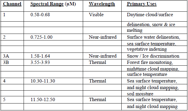
• AVHRR Channels: Channel 1 depends on sunlight reflected on Earth because the sensors is sensitive to visible light. To get visible images, the amount of light reflected must be quite high. Channel 2 detects reflected infrared energy and is the usual visible channel for APT. These two channels are the usually used for APT imagery. Other channels are available for specific use (see figure below). Then the analog signal is processed by the MIRP.
• MIRP: Manipulated Information Rate Processor. At first, the output of AVHRR sensors is amplified and converted to digital information by an analog-to-digital converter (A/D). Then it is processed to create different data streams which match the different signals emitted by the satellite:
-High Resolution Picture Transmission (HRPT): High resolution images with all five channels and telemetry data.
-Global Area Coverage (GAC): Images of all regions of the Earth transmitted to NOAA command and control ground stations on command.
-Local Area Coverage (LAC): HRPT data recorded from selected regions of the Earth transmitted to NOAA command and control ground stations on command.
-Automatic Picture Transmission (APT): Analog transmission of two channels with reduced resolution. In daytime, APT should show visible and IR channels. In night-time, control stations normally set the satellite to replace visible channel by another IR channel with different spectral band as the visible one is no longer useful.