- Table of contents
- 1. Brief history about NOAA satellites
- 2. Poes satellites
1. Brief history about NOAA satellites
The NOAA/POES satellites are monitored by the association National Oceanic and Atmospheric Administration. The NOAA was created in October 1970 for U.S. with the main purpose of provide information about the condition of the oceans and the atmosphere. Concretely, POES satellites send weather information to the National Environmental Satellite, Data and Information Service (NESDIS), which processes and distributes it to the National Weather Service (NWS). NWS is in charge of coordinating the possible warnings to the citizens.
Before the NOAA agency, first meteorological satellite was launched on April 1960 with the purpose of capturing pictures of the Earth from other perspectives. This first mission was realized by NASA. The payload of the satellite, called TIROS 1, was equipped with two slow-scan television cameras, which take pictures of the Earth. During the next years, additional TIROS satellites were launched improving the technology of the instruments. From 1970 onwards, this industry has been managed and governed by NOAA. The organization recollects the data sent by the satellites thanks to the NOAA's satellite system and all the information is archived and distributed to the users. The space segment of the system is provided by NASA. Concretely, the research laboratory Goddard Space Flight Center (GSFC) built and launched the NOAA satellites with all desired instruments.
NOAA's system operates in two types of satellite systems. Both types are indispensable for a complete global weather network. On the one hand, Geostationary Operational Environmental Satellite (GOES) provides continuous information in short-term of weather forecasting, severe storm tracking and meteorology research. These satellites deliver weather information always in the same place of the Earth. On the other hand, the Polar Operational Environmental Satellite (POES) establishes a large-term link for a climate monitoring and weather predictions.
From the beginning many satellites have been launched, but the current satellites have a higher level of performance on their sensors. Nowadays, the NOAA's environmental satellites contain the following nine sensors:
- AVHRR/3 Advanced Very High Resolution Radiometer
- HIRS/4 High Resolution Infrared Sounder
- AMSU-A Advanced Microwave Sounding Unit - A
- MHS Microwave Humidity Sounder
- SEM-2 Microwave Humidity Sounder
- SBUV/2 Solar Backscatter Ultraviolet Radiometer
- DCS 2 Data Collection system
- SAR Search&Rescue Instrument
- DDR Digital Data Recorder
Once the date is received from POES satellites, NESDIS’ Environmental Satellite Processing Center processes these signals into a set of environmental information products that are distributed to the NWS. [1]
The following Figure 1.1 shows a schema with the different organizations and its involvement in the mission.
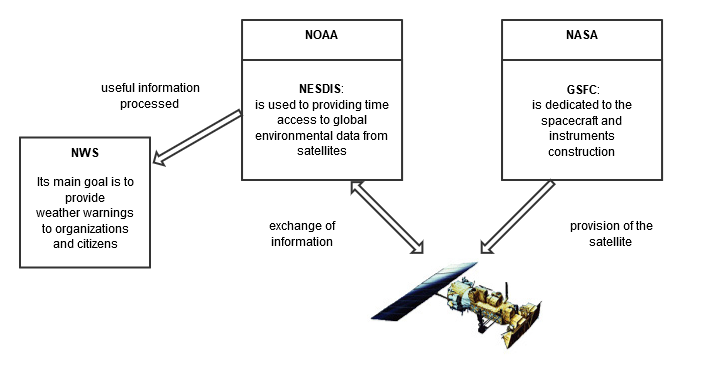
Figure 1.1: Schematic of the different associations
The benefits proportioned by the environmental satellites are to improve the quality of human life and the protection of Earth's environment. The system is able to detect, forecast and monitoring severe storms and national disasters. Also, POES satellites contribute to save lives thanks to the S&R instruments, which are carried on the spacecraft.
2. Poes satellites
The polar-orbiting satellites provide data with infrared and visible Earth images in large-term. There is an important advantage in the polar satellites because they recollect information and images of any place on the Earth. The main characteristics of the orbit are the following:
Nowadays, the fifth generation of these satellites are situated in an altitude over 800 km and they have an inclination around 98^o^, depending of each one. Its orbital periodic is approximately 102 minutes. Therefore, the satellite system is capable of offering 14 polar orbits a day. Each satellite captures different images of a particular place twice a day.
The data received from the POES series supports a broad range of environmental monitoring applications, including for example:
- Climate research and prediction
- Atmospheric soundings of humidity and temperature
- Volcanic eruption monitoring
- Land, ocean and atmospheric applications
Currently, a new generation was launched in 2011. The system called Suomi National Polar-orbiting Partnership predicts severe weather days in advance. It is also used for measurements, as density of vegetation, clouds, ocean colour and surface temperatures.
The payload will be composed of five instruments:- ATMS (Advanced Technology Microwave Sounder)
- VIRS
- CrIS (Cross-track Infrared Sounder)
- OMPS (Ozone Mapping Profiler Suite)
- CERES (Clouds and the Earth's Radiant Energy System)
A new satellite, called JPSS-1, will be launched by the JPSS program in early 2017. The system will be composed of five satellites; therefore, it will improve the accuracy and timeliness of weather event forecasts. JPSS will be able to provide advanced atmospheric temperature and pressure profiles. it will be able to improve the imaging capability to analyze national disasters. [2]


REFERENCES:
[2] JPSS Mission
