
- Table of contents
- 3. Payload
- 3.1. ADVANCED VERY HIGH RESOLUTION RADIOMETER (AVHRR/3)
- 3.2. HIGH RESOLUTION INFRARED RADIATION SOUNDER (HIRS/4)
- 3.3. ADVANCED MICROWAVE SOUNDING UNIT-A (AMSU-A)
- 3.4. MICROWAVE HUMIDITY SOUNDER (MHS)
- 3.5. SOLAR BACKSCATTER ULTRAVIOLET RADIOMETER (SBUV/2)
- 3.6. SPACE ENVIRONMENT MONITOR (SEM-2)
- 3.7. DATA COLLECTION SYSTEM (DCS/2)
- 3.8. SEARCH AND RESCUE (SAR) INSTRUMENTS
- 3.9. DIGITAL DATA RECORDER (DDR)
- 4. Downlink transmission data from POES satellites
- 5. Current NOAA/POES satellites
3. Payload
There are different NOAA satellites, but the current newest payload from the NOAA-N Prime is shown in the picture below due to it carries the latest technology.

Figure 3.0: NOAA-N Prime spacecraft on-orbit configuration [1]
3.1. ADVANCED VERY HIGH RESOLUTION RADIOMETER (AVHRR/3)
The instrument detects the energy in the visible and IR frequencies of the electromagnetic spectrum from the sun, land, sea or atmosphere. For example, the AVHRR/3 is able to discriminate the images from snow, ice and clouds. The information data is obtained through the six-channel imaging radiometer with approximately 1.1 km of special resolution. The Earth surface is scanned from a nadir angle of ±55.4° and using 1.3 milliradianes of instantaneous field of view (IFOV). ITT A/CD is the manufacturer of this device.
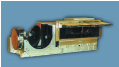
Figure 3.1: AVHRR/ [1] [2]
3.2. HIGH RESOLUTION INFRARED RADIATION SOUNDER (HIRS/4)
HIRS provides atmospheric information by scanning the Earth each 6.4 seconds with an angle of ±49.5°. The instrument measures in the IR frequencies by mean of a set of channels: one visible channel around 0.69 μm, seven shortwave channels from 3.7 μm to 4.6 μm, and twelve longwave channels from 6.7μm to 15 μm. The IFOV per channel is about 0.7°. HIRS’s information data along with data from AMSU instrument is used to compute the atmosphere’s vertical temperature and humidity profiles from about 40 km above the land surface. Due to the HIRS’s data is possible to estimate the temperature of the oceans, ozone levels in the atmosphere, amount of precipitated water, cloud height and coverage and the energy radiated by the Earth’s surface. ITT A/CD, same as the previous one, manufactures HIRS/4.
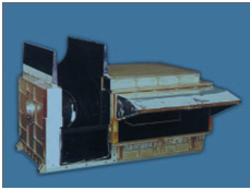
Figure 3.2: HIRS/4 [1] [2]
3.3. ADVANCED MICROWAVE SOUNDING UNIT-A (AMSU-A)
AMSU-A scans the energy radiated at microwave frequencies every 8 seconds. Also, it has an IFOV of 3.3°, which let achieve a special resolution of 48 km at nadir. As previously mentioned, the AMSU-A’s results are used together with the HIRS/4’s data to calculate atmospheric vertical profiles. Two independent modules, called AMSU-A1 and AMSU-A2, compose the instrument and they consist of 13 and 2 channels respectively. Both modules are shown in the image below.
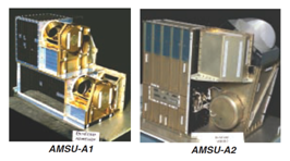
Figure 3.3: AMSU-A [1] [2]
3.4. MICROWAVE HUMIDITY SOUNDER (MHS)
MHS is an instrument recently added to the NOAA-N’s payload and its main function is to obtain the atmospheric humidity profile, as for example, the liquid water contained in clouds. MHS has five microwaves channels; four of them are humidity-sounding channels from 157 to 190 Ghz, and the last is a surface-viewing window channel around 89 Ghz. This instrument has about 16 km of special resolution, which is higher than the resolution achieved by AMSU-A. It was fabricated by EADS Astrium Ltd via EUMETSAT.
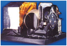
Figure 3.4: MHS [1] [2]
3.5. SOLAR BACKSCATTER ULTRAVIOLET RADIOMETER (SBUV/2)
SBUV/2 is an instrument composed of two modules: Sensor Module and Electronics Module. Its main functions are the measure of the concentration, vertical distribution and photochemical processes at the atmospheric ozone layer, and it also measures the radiated sun energy in the frequency range of 160-400 nm. SBUV/2 is made by Ball Aerospace.
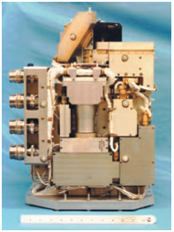
Figure 3.5: SBUV/2 [1] [2]
3.6. SPACE ENVIRONMENT MONITOR (SEM-2)
SEM-2 consists in three modules: Data Processing Unit (DPU), Total Energy Detector (TED), and Medium Energy Proton and Electron Detector (MEPED). The latter two are sensors, the first of which measures the intensity of particles in the range of 0.05 to 20 keV and the second sensor measures protons, electrons and ions in the range of about 30keV-6.9MeV. Therefore, SEM-2 supplies the intensity and flux of the Earth’s Van Allen radiation belt.
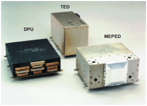
Figure 3.6: SEM-2 [1] [2]
3.7. DATA COLLECTION SYSTEM (DCS/2)
The DCS is a device that receives data from data collection platforms of the earth in the frequency range of 401 610-MHz to 401 690-MHz. The data are transmitted to the satellite in real time and the satellite, which sends the data once per orbit, receives and stores them for later retransmission to the NOAA Command and Data Acquisition (CDA). CDA stations are located in Virginia and Alaska. From there the data is transmitted to earth processing centers, which are located in Maryland and Toulouse. The data extracted from this process are environmental measures, such as, pressure or temperature of land surfaces, as well as, position or activity of ships and animals. Therefore, these data have many different applications.
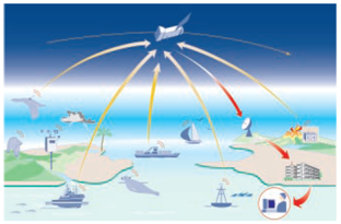
Figure 3.7: DCS/2 [1] [2]
3.8. SEARCH AND RESCUE (SAR) INSTRUMENTS
There are two SAR instruments on-board the satellite: the Search and Rescue Repeater (SARR) and the Search and Rescue Processor (SARP-2). Both of them belong to the international COSPAS SARSAT system, which main function is to provide assistance in emergencies. COSPAS SARSAT system works at 121.5 MHz, 243 MHz, and 406 MHz by using Emergency Locator Transmitters (ELTs), Emergency Position-Indicating Radio Beacons (EPIRBs), and Personal Locator Beacons (PLBs).
After receiving an emergency signal, the device SARR transmits a downlink frequency of 1544 MHz to the Local User Terminal (LUT) on the Earth, which must be in view with the satellite to be able to receive this signal. SARP-2 provides a global detection at 406 MHz by retransmitting the emergency signal to the LUT in the same way as SARR does.
Finally, the LUT receives the information and transmits it to the Mission Control Center (MCC). The MCC processes the signal and alerts the appropriate Rescue Coordination Center (RCC), which is in charge of the rescue work.

Figure 3.8: Diagram of action protocol for a SAR events [1] [2]
3.9. DIGITAL DATA RECORDER (DDR)
The DDR records and stores the measured values for the following three devices: TIROS Information Processor (TIP), AMSU Information Processor (AIP), and Manipulated Information Rate Processor (MIRP). The DDR belongs to the Command and Data Handling subsystem, which its responsible to transmits the information to CDA’ stations after storing the data during each orbit. In order to perform the storage function, it has two memories. These memories are Dynamic Random Access with a capacity of 1.2 Gbits per DDR. L-3 Communications is the company that made this devices.
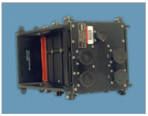
Figure 3.9: DDR [1] [2]
4. Downlink transmission data from POES satellites
SPACECRAFT DATA COMMUNICATIONS
The NOAA satellites have three different protocols to transmit data to the Earth: Command and Data Acquisition Station Downlinks (CDA), Direct Broadcast, and Search and Rescue.
4.1. Command and Data Acquisition Station Downlinks (CDA)
NOAA satellite transmits two different types of data signals to the CDA stations. The data signals are called GAC and LAC.
The first one GAC carries all information data related to one full orbit that is about more than 100 minutes of recorded data. The data contains information about satellite housekeeping, AMSU, and 4 km of resolution AVHRR imagery. [ref].
LAC data signal transports the approximately 10 minutes information recorded by the 1 km AVHRR imagery. If the satellite is within of the footprint coverage, CDA stations can receive real-time information from the satellite.
4.2. Direct Broadcast Downlinks
4.2.1 High Resolution Picture Transmission (HRPT)
HRPT transmits information data from the whole set of instruments onboard the NOAA spacecraft to all Earth Stations within the footprint coverage.
The TIROS Information Processor (TIP), the AMSU Information Processor (AIP), and the Advanced Very High Resolution Radiometer (AVHRR/3) compose the set of instruments. In addition, the TIP instrument takes data from the High Resolution Infrared Radiation Sounder (HIRS/4) , the Space Environment Monitor (SEM-2), the Data Collection System (DCS/2), and the Solar Backscatter Ultraviolet Radiometer (SBUV/2). Also, the AIP device uses data from the AMSU-A and the Microwave Humidity Sounder (MHS) instruments.
People can have easy access to the NOAA data by buying the equipment formed from a pc, an antenna and a specific software.
4.2.2 Very High Frequency (VHF) Beacon Transmission
People get the NOAA data from VHF beacon transmission as a simple way due to the lower data rate of the TIP. Therefore, the equipment required is simpler and users can work with less expensive and complicated technology. The data rate is 8.32 Kbps and the beacon signal is transmitted at 137.35 MHz or 137.77 MHz. [refX]
4.2.3 Automated Picture Transmission (APT) Data
Like the previous method, APT data are transmitted to ground stations within the satellite footprint coverage. ATP transmits data from the AVHRR/3 with a 4 km resolution. The transmitted signal is analogical ("Consisting of an amplitude-modulated subcarrier 2400-Hz modulating the RF carrier frequency at 137.1 MHz or 137.9125 MHz")[refX] and it is transmitted from the NOAA satellite through a dedicated VHF link.
After receiving the signal, the Satellite Operations Control Center (SOCC) selects two of the 5 active channels of AVHRR/3 who are called "Video A" and "Video B". Each line of ATP consists of a line of "Video A" and another of "Video B". The auxiliary data is on the edge of each line. Each line has duration of two seconds and it has a repetition period of 64 seconds. [refX]
Due to the simple and affordable equipment required to receive an APT signal, it is common used for academic purposes.
4.3. Search and Rescue
The program was created in 1979 by Canada, France, USA, and Russia. Subsequently many countries have come together to cooperate and / or benefit from the program. As it has been a bit previously explained in the section 3.8 "Search and rescue (SAR) instruments", the objective of the program is to act in emergency situations. For this, the system detects and sends the warning signs. Thus, a fast acting is achieved and rescue patrols are sent out to save the victims.
Figure 3.7: Logo of S&R: International Cospas-Sarsat Programme [4]
5. Current NOAA/POES satellites
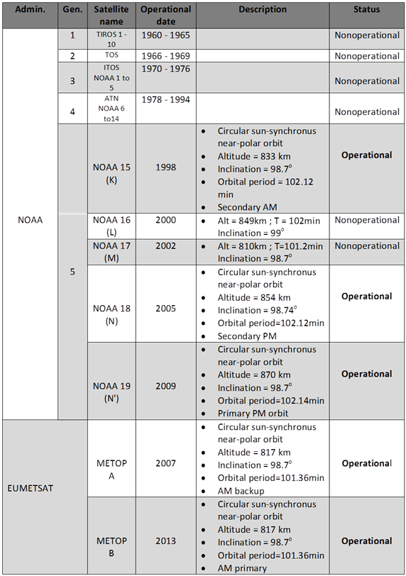
Admin=Administration ; Gen=Generation ; TOS=TIROS Operational System; ITOS=Improved TIROS Operational System; ATN=Advanced TIROS-N; NOAA=National Oceanic and Atmospheric Administration EUMETSAT= European Organization for the Exploitation of Meteorological Satellites
REFERENCES:
[1] NOAA N'
[2] NOAA N
[4] "Search and rescue": http://en.wikipedia.org/wiki/International_Cospas-Sarsat_Programme